5 Ways to Read a Plate Tectonics Diagram

Understanding Plate Tectonics Diagrams: A Comprehensive Guide
Plate tectonics diagrams are a crucial tool for geologists and Earth science enthusiasts to understand the Earth’s lithosphere and its dynamic processes. These diagrams provide a visual representation of the Earth’s surface, allowing us to comprehend the interactions between tectonic plates, which shape our planet’s landscape. In this article, we will explore five ways to read a plate tectonics diagram, helping you to better understand the Earth’s surface processes.
Way 1: Identify the Types of Plate Boundaries
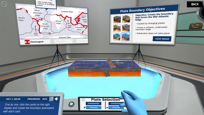
A plate tectonics diagram typically depicts the Earth’s surface as a series of plates that move relative to each other. The first step in reading a plate tectonics diagram is to identify the types of plate boundaries. There are three main types of plate boundaries:
- Divergent boundaries: where two plates move apart from each other, resulting in the creation of new crust.
- Convergent boundaries: where two plates move towards each other, resulting in subduction or collision.
- Transform boundaries: where two plates slide past each other horizontally.
📍 Note: Understanding the types of plate boundaries is crucial in identifying the processes that shape the Earth's surface.
Way 2: Recognize the Symbols and Colors Used
Plate tectonics diagrams use various symbols and colors to represent different features. Familiarize yourself with these symbols and colors to accurately read the diagram. Some common symbols include:
- Arrows: indicating the direction of plate movement.
- Triangles: representing subduction zones.
- Dashed lines: indicating transform faults.
- Colors: used to differentiate between oceanic and continental crust, as well as to represent different tectonic plates.
Way 3: Identify the Major Tectonic Plates
The Earth’s surface is divided into several major tectonic plates. Identifying these plates is essential in understanding the Earth’s surface processes. Some of the major tectonic plates include:
- Pacific Plate
- North American Plate
- Eurasian Plate
- African Plate
- Antarctic Plate
Way 4: Analyze the Plate Interactions
Once you have identified the plate boundaries and major tectonic plates, analyze the interactions between them. Look for areas where plates are:
- Colliding: resulting in mountain building or volcanic activity.
- Pulling apart: resulting in the creation of new crust or rift valleys.
- Sliding past: resulting in transform faults or earthquakes.
Way 5: Consider the Scale and Context
Plate tectonics diagrams are often simplified representations of the Earth’s surface. Consider the scale and context of the diagram to accurately interpret the information. Ask yourself:
- What is the scale of the diagram? Is it a global or regional representation?
- What is the time frame represented? Is it a snapshot of the present day or a representation of the Earth’s surface over millions of years?
What is the difference between oceanic and continental crust?
+Oceanic crust is denser and thinner than continental crust. It is primarily composed of basalt and is formed at mid-ocean ridges. Continental crust, on the other hand, is thicker and less dense, composed of a variety of rocks, including granite and sedimentary rocks.
What is subduction?
+Subduction is the process by which one tectonic plate is forced beneath another. This occurs at convergent boundaries, where a denser plate is pushed beneath a less dense plate.
What is the purpose of plate tectonics diagrams?
+Plate tectonics diagrams provide a visual representation of the Earth's surface, allowing us to understand the interactions between tectonic plates and the processes that shape our planet's landscape.
By following these five ways to read a plate tectonics diagram, you will be able to gain a deeper understanding of the Earth’s surface processes and the dynamic interactions between tectonic plates. Remember to consider the scale and context of the diagram, and to analyze the plate interactions to accurately interpret the information.


